
 De
De 

-
-
-
-
-
-
-
-
-
-
-
-
-
-
-
-
-
-
-
-
-
-
-
-
-
-
-
-
-
-
-
-
Point Clouds
-
-
-
-
-
-
-
-
-
-
-
-
-
Point Clouds
A point cloud is a large set of points in a three-dimensional coordinate system. In most cases, a point cloud is the result of a 3D scanner proceeding. This device allows you to get an idea of the surface geometry of the scanned object.
note: The Point object and the cloud point are different entities in the program.
In addition to coordinates, a point can contain additional information - metadata (attributes). Some metadata is the result of the scanning process (intensity, color, time, etc.), and some is added to the point when working with the cloud (class, normal, etc.).
Point cloud is a separate object, some of its properties can be viewed and edited in the Properties bar. In addition to specialized operations, standard editing commands are available for point clouds, such as move, rotate, scale, mirror, align.
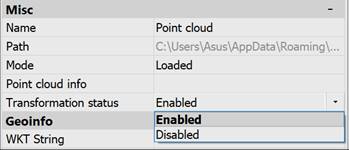
Moving, rotating, scaling, flipping, aligning will be blocked if the Transformation status option is disabled.
You can also set the point cloud loading mode in the Properties bar.
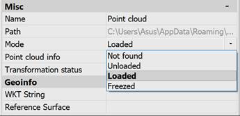
For multi-user network access, it is possible to load a point cloud from an NPC file located on a network resource. When importing a network NPC file, the point cloud data are frozen and the absolute path to the NPC file is set. Any attempts to modify the data of the cloud itself (NPC file) become unavailable, and a link is established to the NPC file that was imported. Together, this allows multiple users to work on a single NPC file. At that, all commands to modify the cloud are fully applicable to such a cloud. A similar possibility to switch the cloud to this mode is provided by changing the Mode property of the Properties bar to the Frozen position. In this mode, the cloud (NPC file) is not re-saved!