
 De
De  Es
Es  Fr
Fr 

-
-
-
-
-
-
-
-
-
-
-
-
-
-
-
-
-
-
-
-
-
-
-
-
-
-
-
-
-
-
-
-
-
-
-
-
-
-
-
-
-
-
Create Geopoints by Interpolation
-
-
-
-
-
-
-
-
-
-
-
-
-
Create Geopoints by Interpolation
Creating Geopoints by Interpolation
 Ribbon: Topoplan – Geopoints >
  Creating Geopoints by Interpolation
Menu: Topoplan – Geopoints >  Creating Geopoints by Interpolation
Toolbar: GeoPoints >  Creating Geopoints by Interpolation
 Command line: NG_CREATE_POINTS_BY_INTERPOLATION
The command creates new geopoints by interpolation between two points specified in the drawing. Several points can be added sequentially. Pressing the ESC key terminates the command.
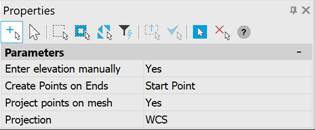
The parameters of the Create Geopoints by Interpolation command are configured in the Properties bar.
|
Enter elevation manually |
Selecting the method for specifying marks. |
|
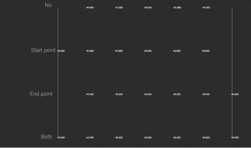
Create Points on Ends |
The mode for adding geopoints in the beginning and end of a line.
|
|
Project points on mesh |
Indicating whether to project points onto the mesh. If Yes is selected, an additional setting appears – Projection. |
|
Projection |
The direction in which the points will be projected onto the surface (WCS, UCS or Viewport). |

Command prompts:
|
Specify the first point or [Settings]: |
Specify the first point of the distance. |
|
Specify the second point or [Settings]: |
Specify the second point of the distance. |
|
Specify points count <1> or [Settings]: [Settings]: Apply changes [Yes/No/save/saveDefault] <Yes>: |
Yes – the command will be performed taking into account the settings changes made by the user in the current command session. No – the command will be performed with the settings that were displayed immediately after the command was launched. save – saving settings to the document. saveDefault – saving settings to the register. |