De
De  Es
Es  Fr
Fr  Pt
Pt 

-
-
-
-
-
-
-
-
-
-
-
-
-
-
-
-
-
-
-
-
-
-
-
-
-
-
-
-
-
-
-
-
-
-
-
-
Creating Surfaces
-
-
-
-
-
-
-
-
-
-
-
-
-
-
-
-
-
-
Creating Surfaces
Triangular Irregular Networks (TIN) have been used in GIS for many years and are a way to digitally represent surface structure. TIN is a form of vector digital geographic data that is constructed by triangulating a set of vertices (points). The vertices are connected by a number of edges to form a network of triangles. There are various interpolation methods for forming these triangles, such as Delaunay triangulation.
The surfaces created can be represented by such objects as SubDMesh, PolyFaceMesh, a collection of Solids, or a collection of 3D Faces.
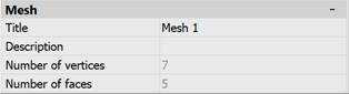
The properties of SubDMesh and PolyFaceMesh objects can be edited in the Properties bar. The Title and Description properties are available for editing. When copying an object, its Title and Description fields are also copied to the new object. The Number of vertices and Number of faces properties are informational.