
 De
De  Es
Es  Fr
Fr  Pt
Pt 

-
-
-
-
-
-
-
-
-
-
-
-
Ground Verification
-
-
-
-
-
-
-
-
-
Ground Verification
 Ribbon: 3DScan – Classification >
  Ground Verification
Menu: 3DScan – Classification >  Ground Verification
Toolbar: Classification 3DScan > Ground Verification
 Command line: PC_GROUND_VERIFY
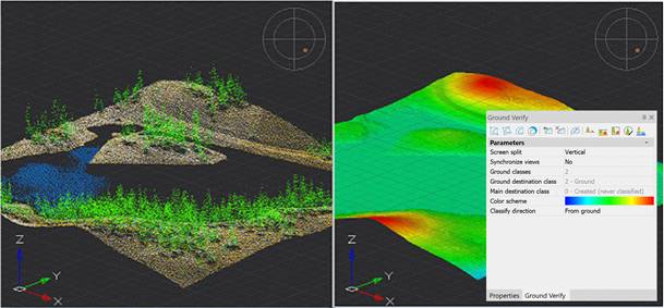
The command allows you to verify classified ground in a point cloud.
The command parameters are available for editing in the Ground verify functional bar.
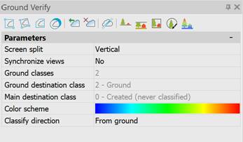
|
Screen split |
· Screen split modes. |
|
Synchronize views |
· To reduce the number of steps when checking large and complex point clouds. The navigation mode is set to either independent (without synchronization) or synchronized. |
|
Ground classes |
· Existing cloud classes that will be involved in earth classification. |
|
Ground destination class |
· The class to be assigned to the recognized ground points. |
|
Main destination class |
· The class to be assigned to recognized model points. |
|
Color scheme |
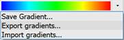
Colors of the future surface. A single click will open a drop-down menu:
· Save gradient – saves the gradient in the current document. · Export gradients – saves the gradient to an XML file. · Import gradients – imports a gradient from an XML file. Double-clicking the gradient image opens the gradient editor. |
|
Classify direction |
· Selection of classification direction. |
The Ground verify window has a built-in toolbar, which is located under the window title.
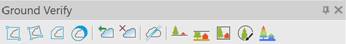
 Cloud clipping commands.
 Clip undo commands. The commands cancel point cloud clipping called from the Ground verify panel.
 Section of a cloud in an arbitrary plane.
 Point cloud classification commands.
 Coloring a cloud by height (Classify by height).
To display the mesh coloring by height, the display of textures must be enabled in the visual style of the viewport (the Show textures checkbox in the visual style editor).